
Poreč/Istria
Poreč/Istria  Approaching Poreč, map of the harbour and prices
APPROACHING POREČ AND MAP OF THE HARBOUR
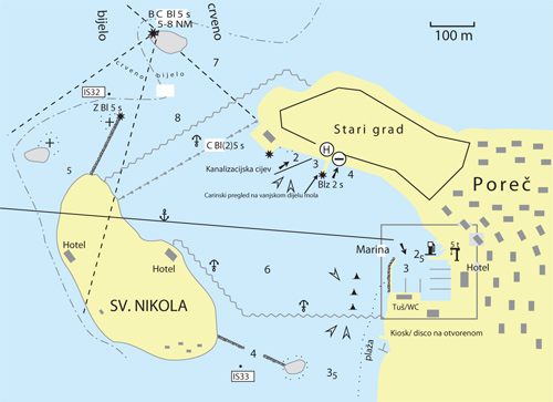
Of the four approaches into the harbour, the safest is the channel between the Barbaran rock and the head of the northern breakwater (on the northern headland off the island of Sveti Nikola). At night, this approached is approached by sailing in the white sector (0620-1530 ) of the light on the Barbaran rock. Smaller vessels can use the other channels, paying attention to the sometimes very strong currents.
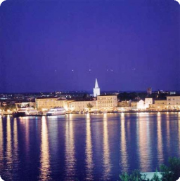
ORIENTATION: the densely wooded island of Sveti Nikola; the bell tower in the town; the light on the Barbaran rock - a red tower with pillar and gallery; the light on the head of the northern breakwater, which from the island of Sveti Nikola in a NNE direction shelters the harbour - a white tower with a green dome.
WEATHER: Southerly and north-westerly winds can cause waves inside the harbour.
FOG: appears on average 10 to 15 days a year, particularly during the winter months.
CURRENTS: the prevailing tides reach up to 0.3 knots. Lon-lasting and strong north-westerly and south-westerly winds can increase the speed of the current to 0.6 knots.
The public transport part of Poreč harbour is intended for the mooring, anchoring and sheltering of vessels up to 500 BRT with a draft of up to 4 metres, for the embarking and disembarking of passengers and loading and unloading of goods and other commercial activities which are connected with these activities commercially, technologically or in terms of transport.
The operative part of the shore south-west of the Riviera hotel is used for mooring boats and small vessels and the embarking and disembarking of passengers and the loading and unloading of goods. From 20:00 in the evening until 06:00 in the morning, this part of the shore, and also the part of the shore south-east of the Riviera hotel, are used for mooring yachts and also boats involved in international traffic.
The part of the shore north-east of the Riviera hotel up to the customs quay is for mooring yachts in transit and vessels used for official purposes.
The western, eastern and southern parts of the customs quay are used for the embarking and disembarking of passengers from abroad and the carrying out of the procedures necessary for foreign vessels to enter the Republic of Croatia.
The part of the shore from the customs quay towards the Zagrebačka banka building is used for the quarter mooring of vessels engaged in excursions and vessels that provide taxi services.
In order to use this part of the shore, vessel owners engaged in excursion and taxi activities must have concluded a contract with the concession holder.
The part of the shore from the break in the shore wall in front of the Zagrebačka banka building to the first stone bollard is used for mooring fishing and sport vessels, for unloading fish and for supplying these vessels. These moorings are used by vessel owners who have concluded a mooring contract with the concession owner.
Owners of vessels whose length does not exceed 20 metres may conclude a contract on mooring for a year.
The anchoring of vessels takes place in an area with equipment for berths. This area is a quadrangular shape. One side is the seaward side of the shore from the Sveti Lovrenc headland to the head of breakwater H in the part of the port for special purposes. The second and third sides are represented by two imaginary straight lines, one of which starts from the head of breakwater H in the special purposes area and goes in the direction of the head of the south-western breakwater towards the island of Sveti Nikola. The other starts from the Sveti Lovrenc headland and goes in the direction of the island of Sveti Nikola. Both sides extend to an imaginary intersection with a straight line that connects the break in the shore wall in front of the Zagrebačka banka building and Serafel rock on the sea side and which constitutes the fourth side of this area. The inside of the Sveti Nikola breakwater - the Serafel rock is used to moor yachts and small vessels.
MAP OF POREČ HARBOUR 

Marina Poreč
Tel: +385 (0)52 451913
- lift 5 tons
- petrol station
Warning: These maps are for information and not navigation purposes.
Source: Karl-H. Beständig "808 LUKA I UVALA - Hrvatska, Slovenija i Crna Gora"
(808 HARBOURS AND BAYS – Croatia, Slovenia and Montenegro)
PRICE PER DAY FOR MOORING - POREČ HARBOUR
| MOORING - TOWN SHORE |
- west of the customs quay
- number of berths: 15
- vessels up to 18 metres in length: 3.4 euros per metre
- vessels from 18 to 25 metres in length: 4.8 euros per metre
- connection to electricity supply and filling water tanks are included in the price
| ANCHORAGE TO BUOYS |
- number of buoys: 15
- vessels up to 18 metres in length: 1.6 euros
- vessels up to 18 metres in length: 1.6 euros
- waste disposal is free
- prices are calculated in euros according to the length in metres of the vessel
Source: http://www.porec-port.com
Video
Current news
 Macrocruise charter agency
Additional discount on the boat rental price of betw


